What's new
Van's Air Force

Don't miss anything! Register now for full access to the definitive RV support community.

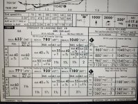
Meridian, MS (LMEI) ILS19 Question

flysrv10

Well Known Member
Does anyone know what KMEI has two Circling Minimums? and when one might use one over the other?

How about "*#" symbol?

Thank you. Rob.
 

Attachments

  • KMEI_ILS_19.pdf
    471.3 KB · Views: 74
The * is for localizer only step down altitude because if on ILS you would be flying the glide slope if inside the final approach fix. The # is referencing the Hattiesburg altimeter setting if the field altimeter setting is not available. It looks like the second circling minimum is for the Houlin fix (as it says) and the first circling is if you cannot identify Houlin for some reason…DME is required and GPS is required in the terminal area but it doesn’t say you need GPS to fly the approach. That’s my best hack at this!
 
Last edited:
You'll notice there is an obstacle between GOZAX and HOLUN just left of the approach course at 710 ft. If your able to identify HOLUN, then you can be assured the obstacle is behind you, and the approach designer permits a lower MDA. If you can't, then you remain at the higher circling MDA.

My old garmin 300XL doesn't have step down fixes in the database that are beyond the FAF, but I can use DME to the missed approach point to determine when I've passed them. I think modern GPS units have probably every published fix in their databases nowadays.
 
Last edited:
I attached the minimums section from the Jepp plate. It is slightly better at depicting the answer.

If you use the HOLUN fix, there's the minimums
If you don't use the HOLUN fix, there's the higher minimums

Girraf in the post above describes one situation where one might not use the HOLUN fix
 

Attachments

  • 20240107_093943.jpg
    20240107_093943.jpg
    419 KB · Views: 28
Back
Top