Not correct but you are not totally wrong.... I did it. It works great. There is a document on GRT web site under misc.
https://grtavionics.com/media/StratuxSupplement.pdf
There is also a download of a patch or image you load onto the Stratux via WiFi from your iPad or Tablet.
I used the TRENDnet TU-S9 USB to Serial adapter. That is the one GRT recommends. You can get adapter from GRT or other retailers, $15-$30.
Yes it can be done and yes it is a tiny pain in the empennage to get at the one remaining USB port on the raspberry pie for SERIAL OUT data to your EFIS. However worth it for ADS-B TIS (both 978 MHz or 1090 MHz) and WX (1090 Mhz). I did it without major moving of stuff (kind of).
First what I did NOT do but apparently works and likely what you are referring to. You replace the internal USB GPS card (inside the case) and use a VK162 USB GPS, a remote USB GPS on the end of a USB cable. Looks like a corded computer mouse. This replaces the wide GPS card. The USB plug for the VK162 does not block the adjacent USB port. However you need to route the cable out of the case. This will allow free access to the 4th USB port to plug in a USB to serial adapter directly, There are two recommended but GRT and I recommend the one below. However you do have to route the cables for the GPS and USB/Serial adapter out of the case which takes some case modification (not much). I did NOT do this...
I kept the GPS card, Stratux GPYes 2.0 u-blox 8 USB GPS Unit with external antenna jack (in addition to on board antenna. The VK172 GPS card is narrow but not as good. It has a smaller antenna and no external jack, but makes space to access USB port 4. I did not want to compromise strong GPS performance. There or two versions of the Stratux GPYes 2.0 u-blox 8 USB GPS on with external antenna jack and on without. I have external antenna option.
The problem is the USB/GPS card blocks that 4th USB slightly, and typical USB cables have very chunky and long molding at the connector. There are some USB cables that have slim trim connectors but still would require whittling (grinding) on the connector. I went a different way. Although there are some pretty trim USB cables (see below) I have yet to try I made my own cable.
There are 4 USB's on the Raspberry Pi*, 3 are used, two for SDR (software defined radios) and one for GPS. You need to add USB to Serial adapter to 4th and last open USB port. There are several work arounds. My solution was two fold:
One made an ever so slight trim on the edge of the internal USB GPS card. It is a no brainer and almost not needed with part two below.
Two - I bought Male USB Type A connector made for circuit board I believe. The connector is short and it has no plastic molding (see picture / link below). I soldered onto the stub USB (type A) male connector cable extension with female USB A connector. It was easy to solder and heat shrink made it tidy. I made a slight mouse hole on the upper case cover to route the USB cable (female) out of case. The TU-S9 USB to serial adapter USB plugs nicely into my cable extension. In case GPS still installed. It works. My set up can be undone and put the Stratux back into portable config. It is still portable just with the cable hanging out of it, but I can remove cable and go back to original. The mouse hole in case top does not affect overall appearance. I can buy a new case cover, the whole case for $17. It does take some assembly and disassembly to get at it.. but doable.
If you DO NOT have Stratux already consider a different route. However in my case I already had a Stratux made by Crew Dog. They are now $400. I got mine pre "panorama" at almost half that. I was going to make my own, but by the time I bought all the parts it was going to be a good chunk of just buying the CrewDog turn key. The CrewDog, came with battery, accessories. So I had it, and I am using it. I got a 12v to 5v USB adapter to power the Statux.
If you do NOT have a Stratux already like I did consider the GRT Avionics ADS-B "Discovery" receiver. It is about $500, but made for permanent installation. If you have Garmin or Dynon you may want to check, they are picky and proprietary about interfaces.
There are transponders with ADS-B Out and IN already. They tend to be expensive but a clean all in one solution.
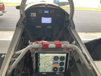
The Stratux has WIFI and will send data to your iPad or Tablet. I did my set up for under $300. Also you can tell the Stratux to ignore or suppress your plane. The GRT has sttings to do that as well.
This is the magic connector (magic as in solved the space issue)
USB 2.0 Type A Male Socket Connector Repair Adapter Board Mount. (digikey, amazon, ali express, ebay)
Amazon is 100 for $10, You can buy smaller quantities (10 for $6). This is just an example, but if you have Prime it may be OK.
Ali Express 10 for $1 free shipping. DigiKey is good if you already have an order with them.
You still have to fabricate a female USB extension cable. I cut the chunky male end off a cable of a high quality male to female extension cable, soldered on my magic USB stubby connecter. It, hurt a little but worked out great.
The other idea, and I bought it on Ali Express, still waiting to get it, is this low profile right angle extension. This guy will require surgery on case but again can be undone, albeit with a bigger MOD to case than above cable I already made. This was a backup plan. I likely will not incorporate, since my cable worked out well. If it ain't broke don't fix it.
5cm-300cm USB 2.0 A Plug to Male&Male/Female 90 Angled Extension Cable USB 2.0 Male to Female Right/Left/Down/Up Black Cable

photos.app.goo.gl
* FYI for those who did not know... Raspberry Pi is not only a delicious dessert but a general use Micro processor and operating system that reads program off a SD card. It can do whatever you want. Hobbyist do some neat things with them. I am not one of those enthusiast but it is cool. One group is Stratux, which is an OPEN SOURCE project that turns the Pi into a ADS-B receiver with plug in USB modules, radio receivers and GPS. It has a huge user group support. You can make your own, buy parts. The software is free. The program is stable and the "official release" is vetted. Updates are not as often as it is a mature platform. However late last year they did update it. It is not a must have update but nic to have. The Raspberry Pi comes in different flavors, pun intended, but the one I have, has a built in AHARS (yes you can get attitude, pitch and roll) and WiFi. WIFI is the the main way you talk to and get info from the Pi. However for EFIS that needs a RS232 input to get ADS-B data, you have to fit a USB to RS232 adapter. Now you have a nice ADS-B receiver for traffic and weather for both your panel mounted EFIS and your tablet via WiFi... There are many ways to get ADS-B in, some expensive. The Stratux is low cost but requires some work. . I have $250 to $300 in my ADS-B in setup all up. It works well. No compromise in function or quality and quantity of data. It runs at 115200 baud btw. ADS-B in is ADS-B in. However note, if you are NOT sending OUT ADS-B you may NOT always see other ADS-B traffic. It is analogous to your transponder does not reply unless radar interrogates it. If the ADS-B out does not get ping from ground tower or another plane it may be silent. ADS-B traffic is not a substitute for looking out the canopy.


")

